 Can you think of a brother and sister weather pattern pair that are opposite in every way, have triggered one out of five civil wars since 1950, and have the ability to change the climate across more than 50% of the Earth?
If you guessed El Niño and La Niña, you are right! Together they exercise the strongest influence on Earth’s climate during winter in the Northern Hemisphere.
Last month, the National Oceanic and Atmospheric Administration’s Climate Prediction Center (NOAA) observed La Niña conditions emerge in the Pacific Ocean.
What is La Niña and how will it impact the United States? Let’s take a look!
The ENSO Cycle
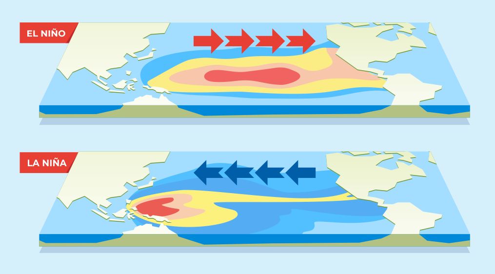
 El Niño and La Niña are opposite phases of the El Niño/La Niña Oscillation Cycle (ENSO). Driven by winds (called the Easterlies), the ENSO cycle creates a temperature variation between the two ends of the tropical Pacific Ocean.
The cycle consists of three phases: the neutral phase, El Niño, and La Niña.
- During the neutral phase, the low altitude Easterlies blow from the American continent in the east to Oceania (Australia, New Zealand, and other Pacific islands) in the West, taking warm waters with them. As a result, the sea temperatures closer to Oceania rise. In a process known as “upwelling”, waters closer to America are replaced by deep, cold, nutrient-rich ocean water -- thus lowering regional temperatures.
- The El Niño phase is a warm event where the Easterlies weaken, leading to decreases in upwelling near America. During El Niño, warm water is pushed back toward the west coast of America, typically around December. Since this event was first discovered around Christmas time, it was christened “El Niño” after baby Jesus. El Niño typically results in warmer and drier weather in the Northern U.S. and Canada and flooding in the Gulf Coast and the Southeast. Across the Pacific, this condition can lead to droughts in Australia.
- La Niña is an opposite cold event where the Easterlies become very strong. More warm water is pushed towards Oceania, and the upwelling near the Americas increases. This leads to more flooding in the Pacific Northwest and Canada and droughts in the U.S. Southwest. It is also known to cause more severe hurricanes. Across the Pacific, this condition can lead to heavy rainfall in Australia and a stronger monsoon in India.
Both El Niño and La Niña have far-reaching effects, beyond the Pacific basin and all over the world. Besides affecting millions of people, the ENSO cycle can spread diseases like malaria and dengue and bleach coral reefs. These events occur every two to seven years and can last up to two years.
The ENSO cycle has existed for tens of thousands of years on our planet but climate change is contributing to wetter and more serious El Niño and La Niña events.
Fortunately, technology like geostationary environmental satellites enables scientists to accurately predict El Niño and La Niña events.
 The La Nina Forecast for 2021
By looking at the developing conditions, NOAA predicts that La Niña will be in effect from December 2021 to February 2022.
2021 will be the second La Niña year in a row, a phenomenon known as “double dip”. Wetter conditions are predicted for the Northwest - the Rockies, Great Lakes, Ohio Valley, and Alaska. Temperatures are also expected to drop in these regions. The Southwest will continue to experience little precipitation and drought conditions.
However, scientists tell us that it is not possible to make definitive predictions. There is a high probability of these conditions occurring as another La Niña year unfolds.
Sources: NOAA, NPR, NY Times, NatGeo, climate.gov


