Satellites are already in use for so many purposes today - from weather forecasting to communications, GPS, and more.
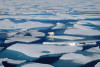
Since the late 1970s, satellites such as the European space agency’s (ESA) CryoSat-2 and the US space agency’s Icesat-2, have also been used to monitor changes in the Arctic sea ice.
Data suggests that sea ice is thinning over time due to climate change. Over the last forty years, the extent of Arctic ice cover has been declining at a rate of 13% per decade. However, existing ways of measurement do not provide a clear and continuous picture of the state of sea ice.
This September, scientists developed a new method that combines computer modeling and satellite data to predict ice thickness - all year round. Let's find out more and the impact of this new research.
Background & Current Methods
Over the years, scientists have proposed several methods to measure ice thickness. These include flying planes over the Arctic Ocean or collecting field measurements (scientists collecting data in person).
 Neither of these methods provides a full picture of Arctic melt, making year-long data collection difficult. Continuous data across the entire region from satellites is a great way for scientists to understand how climate change is playing out in the Arctic.
These satellites use special radar or laser-based altimeter instruments. Sea ice thickness is then calculated as the difference between the height of the ice and the top of the water (ice level - sea level). This method works well during the winter months - September to May.
Unfortunately, satellite-based sea ice thickness measurements are inaccurate, during the summer months: the time of the year with the greatest melting. This melting creates a pool of liquid water on the surface. As a result, the simple calculation (ice level - sea level) does not work as radar systems are unable to differentiate between ocean water and ice, thus rendering measurements inaccurate.
New Research & Impacts
 New research led by Jack Landy, a scientist at the University of Tromsø — The Arctic University of Norway — seeks to tackle this age-old issue. The team used machine learning and deep learning methods to distinguish between seawater and ice.
The researchers built a model of the radar system’s predicted data and cross-referenced these values to those collected by a satellite. This model allows the researchers to obtain accurate, year-round Arctic sea ice thickness data.
Why is this important?
- This is beneficial to the shipping industry for forecasting routes and traffic.
- Melting ice affects the Inuit communities of the Arctic and this approach can be used to map safer routes, thereby avoiding accidents.
- Since thinner ice melts faster, this information can be used to make predictions about the Arctic’s future.
- Melting ice increases sea levels, which furthers the risk of coastal erosion. Increasing sea levels combined with warming air create more coastal storms, such as hurricanes and typhoons. These projections may be used to identify at-risk coastal communities.
According to Dr. Michel Tsamados from University College London, the new advanced climate model “will improve both short-term forecasts for the weather at the mid-latitudes and the long-term forecasts that show what climate we will have in the future.”
Sources: BBC, Scientific American